
Copper Mining in Arizona
The legacy of mining is etched into the landscape and history of Arizona. It is part of the culture, economy, and environment. Indeed, copper is showcased as one of the “Five Cs” upon which the Arizona economy was founded. These five industries – cattle, cotton, citrus, climate, and copper – are represented on the Great Seal of the State of Arizona.
Arizona produces approximately 65% of the country’s copper (AZGS, 2014). In 2011, copper mining contributed $4.6 billion in direct and indirect economic benefits to the state, generating 49,800 jobs (AZ Mining Assoc., 2011). Arizona is home to the Morenci Mine, owned by Freeport-McMoRan, which is one of the largest copper mines in the world (Freeport-McMoRan, 2014).
There are 27 major mines in Arizona, including 10 major copper mines which produce 23 to 632 million pounds of copper per year. Of interest, only two of the 10 major copper mines are located north of Phoenix; the rest are located in the southeastern part of the state. In addition, there are two proposed major mines, which are waiting for special permitting to be approved to begin production: Rosemont Copper Mine near Tucson, AZ (on lands sacred to the Tohono O’odham and Pascua Yaqui Tribes) and Resolution Copper Mine near Superior, AZ (on lands sacred to the San Carlos Apache and related Tribes).
Environmental Regulation of Copper Mining in Arizona
The main environmental protection agencies which govern a mine’s potential to contaminate the local environment include the Arizona Department of Environmental Quality (ADEQ) and the United States Environmental Protection Agency (US EPA). These two agencies, as well as county or other local agencies, ensure that operating mines, as well as mines which have been closed, do not release contaminated or hazardous materials outside of the mine site. Hazardous materials have the potential to leave a mine site through wind, which can carry dust; rain, which can flow in washes and streams; and in the groundwater, which can contaminate the local drinking water. If hazardous materials or contaminated water were to leave a mine site, mine owners could face very large fines on a daily basis, be rejected for future permits, and even face time in jail. Mines on reservations must meet environmental quality standards set out by the respective reservations. For instance, the Navajo Nation Environmental Protection Agency (NNEPA) has well-defined water and air quality standards, which the mines must comply with. Many of the laws in NNEPA are modeled after the US EPA; companies working in such areas often follow the governing body with the strictest policies to ensure adequate environmental compliance. If there is no formal tribal environmental protection agency, the mines will be governed by the US EPA. Typically, mining companies will have environmental engineers on staff at the site or use environmental consulting firms to interact with the regulatory agencies.
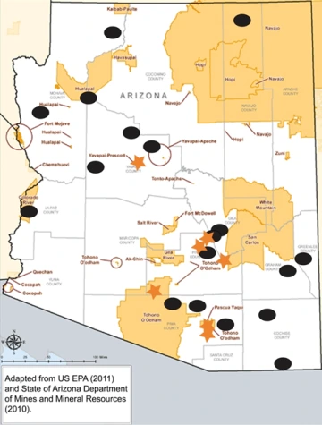
Major mines (black ovals), major mines on tribal land (orange stars), and tribal reservations (light orange areas) in Arizona.
Copper Mining on Tribal Lands in Arizona
Twenty-one federally-recognized tribes own lands that cover 19.7 million of Arizona’s 72.9 million acres, or 27% of the state. Currently, there is only one active copper mine on designated tribal lands in Arizona, the Mission Mine (see Case Study #1). The Mission Mine is operating on both privately owned land as well as lands owned by the Tohono O’odham Reservation and pays royalties on the copper extracted there. In addition, the Cyprus Tohono Mine (see case study #2) may resume operations.
Tohono O’odham Nation
The Tohono O’odham tribe owns 2.7 million acres, or 3.7% of the state. Metallic minerals mined on or near the Tohono O’odham reservation throughout history include copper, gold, silver, lead, zinc, iron, mercury, manganese, uranium, and tungsten. There are approximately 210 metallic mineral deposits, prospects, and quarries within the Pima County portion of the Tohono O’odham Nation. However, many of the smaller mines are the results of small-time prospectors and have since been abandoned. The two most prominent mines include the Mission Mine and the Cyprus Tohono Mine.
Tribal Concerns with Mining
Throughout history, tribes have faced displacement, discrimination, and marginalization due to mining on their lands (Ballard, 2003). The copper mining industry is an important source of wealth and employment in Arizona (AZ Mining Assoc., 2011). Yet, without proper planning and environmental monitoring, mining can also be a source of contamination that impacts the health of neighboring communities and the environment (US EPA, 2011). Environmental health is an important concern for communities living near mine sites, including tribes. Many times these communities are exposed to poor air quality, contaminated water, and occupational hazards (Azapagic, 2004). In general, the occupational health and safety risks are above average for the mining industries. Such risks can include chronic occupational diseases which can be a result of direct exposure to dust during metal/mineral extraction (Azapagic, 2004). These risks can be greatly reduced with the proper use of Personal Protective Equipment (PPE) which, under law, must be worn by those with a risk of exposure (Merrifield, 2013). The enforcement of such laws, and other mine safety issues, is regulated by the Mine Safety and Health Administration (MSHA), a division of the US Department of Labor.
The impacts of mining on sacred lands and artifacts are also of concern for tribal communities. Although U.S. laws for the most part protect sacred lands on and off tribal reservations, there are still potential risks for loss. For example, traditional livelihoods may be limited due to lack of access to land and/or destruction of important resources (e.g., mountains, vegetation, wildlife). Tribal communities often rely on natural resources found on sacred lands for cultural, medicinal, and spiritual purposes. For example, on the Navajo Nation in northeastern Arizona and southeastern Utah, Navajo people living in and near uranium mining areas used mill tailings, a sandy waste containing heavy metals and radium, which is radioactive, to build their traditional earthen homes (hogan), many of which remain in use today (DOE, 2013). Another example is the nearly 100 sacred and cultural sites of the Tohono O’odham Nation, which may be impacted by the proposed development of the Rosemont Copper Mine in southern Arizona (Tohono O’odham, 2009). A final example is the Oak Flat area east of Superior, AZ, lands sacred to the San Carlos Apache tribe, where Resolution Copper is proposing to mine (Allen, 2015). Innovative mining companies implementing responsible mining have recognized the need for more respectful relationships with tribal nations to ensure that when mining is undertaken, the rights and interests of the People are considered. For more details on U.S. laws protecting sacred lands, refer to the “Mining-Induced Sociocultural Impacts” module.
Case Study #1 - Mission Mine (ASARCO):
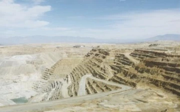
Mission Mine. Photo Credit: 2011-03-2897, ADMMR Photo Archive, Arizona Geological Survey.
Mission Mine. Photo Credit: 2011-03-2897, ADMMR Photo Archive, Arizona Geological Survey.The Mission Mine is situated on 19,000 acres (29.7 square miles) of land in Sahuarita, AZ, 18 miles south of Tucson. The mining complex is comprised of the Mission, Eisenhower, Pima, Mineral Hill and South San Xavier properties and the nearby North San Xavier mine (ASARCO, 2014). While most of the mining property is owned by ASARCO, a portion of the mine complex is located on the south end of the Tohono O’odham San Xavier District and is leased to ASARCO by the Tohono O’odham Nation. The open-pit copper mine is approximately 2.5 miles long, 1.5 miles wide, and 1,200 feet deep, with 40-foot-highbenches (narrow, step-like strips cut into the side of the open pit). Early copper mining began at the site in 1900, with open pit stripping beginning in 1959. In 2012, the mine produced 134 million pounds of copper concentrate, paid $6.6 million in state royalties and $2.5 million in tribal royalties, and employed 620 people. The mine is expected to produce until 2033.
A reclamation plan for the Tohono O’odham portion of the Mission Complex details how different sections of the mine will be reclaimed both during and after active mining. For waste rock dumps and mine tailings, reclamation will include soil capping and rainwater capture to support revegetation with native plants (Gault Group, 2008). The Tohono O’odham Nation is also working with US EPA to develop renewable energy (solar panels) on a portion of the mine tailings.
Since the mine is on both private and tribal lands, ASARCO is required to file for permits with the US EPA, ADEQ, and the Pima County Dept. of Environmental Quality (PDEQ). As discharges from the mine enter unnamed tributaries and ephemeral washes of the Santa Cruz River, one of the permits is for the discharge of mine drainage and stormwater. ASARCO has been issued several notices of violation for discharges containing copper, lead, and other metals. They continue to work with the regulatory agencies to achieve compliance through construction and maintenance activities to limit additional discharges. Another permit is related to dust emissions from the mine tailings. Violations of air quality rules in 2009 and 2013 led to assessments of fines and ASARCO has taken measures to control the tailings dust and limit additional violations.
For more information about the Mission Mine complex:
US EPA ASARCO Mission Complex Fact Sheet
US EPA Renewable Energy Development Opportunities ASARCO Mission Mine Tailings Area
ADEQ Draft Fact Sheet, Pollutant Discharge Elimination System permit for ASARCO Mission Complex
PDEQ ASARCO Mission Complex Mine Tailings Dust webpage
Case Study #2 - Cyprus Tohono Mine (Cyprus Tohono Corporation, a subsidiary of Freeport-McMoRan Copper & Gold, Inc.)
Cyprus Tohono Mine, historical photo. Photo Credit: 2011-03-6237, ADMMR Photo Archive, Arizona Geological Survey.The Cyprus Tohono Mine is located 32 miles south of Casa Grande, AZ, near the town of North Komelik in the Sif Oidak District. It is situated on 4,180 acres of land leased from the Bureau of Indian Affairs and the Tohono O’odham Nation. The copper mine and processing facility, formerly known as Casa Grande Mine and Lakeshore Mine, has been operated by several different companies since the 1880s. Open pit mining began in 1959 and underground mining began in 1970. Both oxide and sulfide ores were mined and processed. Open pit mining ended in 1997, and in 1999 the facility transitioned into care and maintenance mode. The Cyprus Tohono Corporation is currently considering resuming operations.
In 2009, the site was listed as a Superfund Alternative Site because of a groundwater plume contaminated with uranium, sulfate, and perchlorate extending one-half mile from the site. The US EPA has been investigating the site and considering options for clean-up. In response to a request from the US EPA and the Tohono O’odham Nation, the Agency for Toxic Substances and Disease Registry has completed a Health Consultation regarding human exposures and possible health impacts (ATSDR, 2014 and ATSDR, 2014).
For more information about the Cyprus Tohono Mine: US EPA Cyprus Tohono Mine Site Overview